Zion And Surrounding Area Guide
-
rock art hiking / walkingPetroglyphs on boulders at the Santa Clara River Reserve
-
-
trailhead hiking / walkingShort, scenic hike that is popular (parking fills fast); dino prints nearby
-
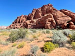
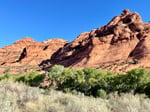
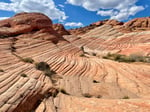
trailhead hiking / walkingProvides access to the scenic Candy Cliffs area
-
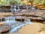
trailhead hiking / walkingSemi-technical wet slot canyon requiring a permit
-
-
trailhead hiking / walking
-
trailhead hiking / walking
-
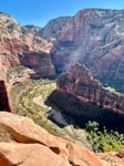
trailhead hiking / walkingShort trail on Zion scenic drive that leads to an overlook
-
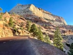
scenic driveRt 9 from Springdale winds through the park to the East Entrance Ranger Station
-
campgroundState park campground convenient to St. George and Zion.
-
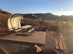
campground hiking / walkingSmall, secluded BLM campground near dinosaur footprints and Red Reef trailhead.
Last updated: December 22, 2024
Petroglyphs on boulders at the Santa Clara River Reserve
want to go
rock art
hiking / walking
More ...
|
View on Google Maps
Short, scenic hike that is popular (parking fills fast); dino prints nearby
trailhead
hiking / walking
More ...
|
View on Google Maps
Provides access to the scenic Candy Cliffs area
trailhead
hiking / walking
More ...
|
View on Google Maps
Semi-technical wet slot canyon requiring a permit
trailhead
hiking / walking
More ...
|
View on Google Maps
Short trail on Zion scenic drive that leads to an overlook
want to go
trailhead
hiking / walking
More ...
|
View on Google Maps
Rt 9 from Springdale winds through the park to the East Entrance Ranger Station
scenic drive
More ...
|
View on Google Maps
Small, secluded BLM campground near dinosaur footprints and Red Reef trailhead.
campground
hiking / walking
More ...
|
View on Google Maps