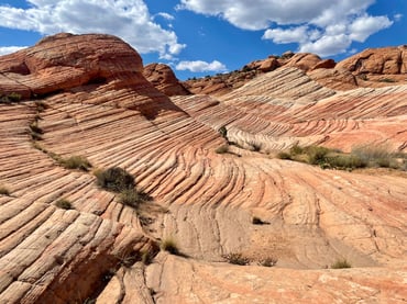
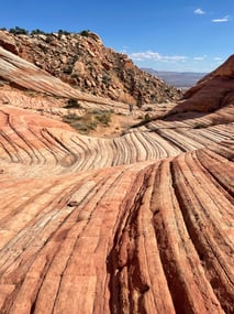
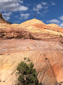
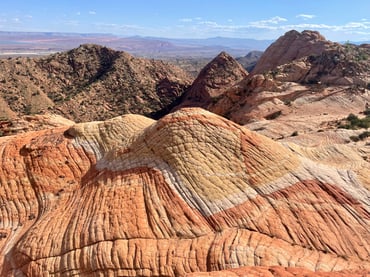
Candy Cliffs (Anna's Viewpoint) trail at Yant Flat
trailhead
hiking / walking
Provides access to the scenic Candy Cliffs area
Notes from visits
-
- ~4-5 miles; longer if want (navigate through a bunch of trails to a distinct, worn trail)
- Highlight was Yellow Top (follow Gaia trail, which curves to the left after arriving at the slick rock and goes down into a drainage; see greatamericanhikes description)
- Can visit near sunset for good photos (but beware the drive back)
- Access:
- Accessible with a high clearance vehicle; road was decent when we went (don't go in rain; slow/bumpy; may have to ford small streams but we didn't; steep cliff edge to navigate without guard rails but it was fine if you are comfortable with this)
- From St. George, take I-15 North to Leeds, Utah. Take Silver Reef Road (which becomes N Oak Grove Dr) to Danish Ranch Road. Google will take you to Yant Flats Trailhead / Anna’s Viewpoint Trail. No signs mark parking; you pass Yankee Doodle Canyon just before the trailhead
- Tip: Call the Pine Valley Forest Ranger for info on road conditions before heading out - 435-783-4338
More info
Last updated: October 30, 2024
Petroglyphs on boulders at the Santa Clara River Reserve
want to go
rock art
hiking / walking
View on Google Maps
Short, scenic hike that is popular (parking fills fast); dino prints nearby
trailhead
hiking / walking
View on Google Maps
want to go
trailhead
hiking / walking
View on Google Maps
want to go
trailhead
hiking / walking
View on Google Maps
Short trail on Zion scenic drive that leads to an overlook
want to go
trailhead
hiking / walking
View on Google Maps
Rt 9 from Springdale winds through the park to the East Entrance Ranger Station
scenic drive
View on Google Maps
Small, secluded BLM campground near dinosaur footprints and Red Reef trailhead.
campground
hiking / walking
View on Google Maps